All posts by wehitoil-admin

General Information: Dewitt County

Dewitt County lies at about forty-five miles from Copano Bay, on the Gulf Coast Plain in southeastern Texas. Cuero is its county seat and its largest town. Named after Green DeWitt, an empresario, the county comprises 910 sq. mi. and is bounded by the counties of Victoria, Goliad, Karnes, Gonzales, and Lavaca.

For the past two decades, oil wells in Dewitt County were not much productive until the oil boom which began in 2010. Since its production history, 5,086 wells have been drilled. Dewitt County has produced 4,736,344 barrels of oil as of August 2014 – the highest recorded yet – and is showing a lot of promise. So far, there are 774 producing leases and 62 producing operators. Burlington Resources O & G Co. LP, Chesapeake Operating Inc., Devon Energy Production Co. LP, and Sabine Oil & Gas LLC are some of Dewitt County’s top producing operators.

Top Leases in Dewitt County, TX:

  • Burlington Resources O & G Co LP
  • Chesapeake Operating, Inc.
  • Devon Energy Production Co, L.P.
  • Encana Oil & Gas(USA) Inc.
  • EOG Resources, Inc.
  • Geosouthern Energy Corporation
  • Magnum Producing, LP
  • Marathon Oil Ef LLC
  • Matador Production Company
  • Pioneer Natural Res. USA, Inc.
  • Remora Management, LLC
  • Rosetta Resources Operating LP
  • Sabine Oil & Gas LLC
  • Statoil Texas Onshore Prop LLC
Operator Number Operator Name Location Leases
953562 1776 ENERGY OPERATORS, LLC Houston, TX 77070 1
953637 1988 INDEXGEO JV
953747 3-G OPERATING COMPANY Houston, TX 77244
403070 403070 – NAME UNKNOWN
953762 5-D OPERATING INC Yorktown, TX 78164
000202 A & D EXPLORATION COMPANY Rockport, TX 78381 5
000253 A.J.& M. OIL COMPANY Flatonia, TX 78941
000555 A.O.E. OPERATORS, INC. Fulshear, TX 77441
000894 ABACO OPERATING, LLC San Antonio, TX 78209
001690 ABERCROMBIE-BIRDWELL
003125 ABRAXAS PETROLEUM CORPORATION San Antonio, TX 78258 6
003645 AC EXPLORATION, LLC Houston, TX 77024
003642 AC PRODUCING, LLC
003596 ACOCK OPERATING LIMITED San Antonio, TX 78217
003599 ACOCK/ANAQUA OPERATING CO., LP Corpus Chrsti, TX 78401
003673 ACTIVA RESOURCES, LTD.
003925 ADA RESOURCES, INC.
007320 ADAMS, ROBERT L.
008380 ADOBE OIL & GAS CORP.
008725 AGOIL, INC. Victoria, TX 77901
010074 ALAMO OPERATING COMPANY, L. C. San Antonio, TX 78217
011285 ALCORN PROD CO.
015050 ALLTEX EXPLORATION, INC. Houston, TX 77056
015141 ALPINE RESOURCES, INC.
016945 AMEND ENERGY COMPANY
016980 AMERADA HESS CORPORATION
018008 AMERICAN COMETRA, INC.
018395 AMERICAN INT’L ENERGY CORP.
018900 AMERICAN PETROFINA CO. OF TEX.
018966 AMERICAN PUMPING & TRUCKING New Braunfels, TX 78131
019365 AMERICAN SHORELINE, INC. Corpus Chrsti, TX 78401
020463 AMPAK OIL COMPANY Plano, TX 75074
020569 ANAQUA OIL & GAS, INC.
027200 APACHE CORPORATION Houston, TX 77056
027815 APPELL PET. CORP., ETAL
028671 ARANSAS DRLG & WORKOVER CO INC Corpus Chrsti, TX 78409
028801 ARAXAS EXPLORATION, INC.
028734 ARCADIA OPERATING, LLC Kilgore, TX 75663 6
028730 ARCADIA REFINING CO.
029340 ARCO OIL & GAS CO.
029390 ARCTURUS OPERATING COMPANY Dallas, TX 75254
030790 ARKLA EXPLORATION CO.
033149 ARRINGTON OIL&GAS OPERATING LLC Midland, TX 79702 2
033148 ARRINGTON,DAVID H. OIL & GAS,INC Midland, TX 79702
034380 ASHFORD OIL & GAS COMPANY
035633 ATAPCO
036103 ATKINSON ENERGY CORPORATION
036550 ATLANTIC RICHFIELD CO.
036562 ATLANTIS OIL COMPANY, INC. Tyler, TX 75701
036742 AUBURN ENTERPRISES, INC.


References:

“Oil Wells and Production in Dawson County, TX.” Dawson County, TX Oil Wells, Operators, and Production Data. Texas Data Applications, LLC. Web. 1 Feb. 2015. <http://www.texas-drilling.com/dawson-county>.

Roell, Craig H. “DEWITT COUNTY.” Handbook of Texas Online. Texas State Historical Association, 12 June 2010. Web. 31 Jan. 2015. <http://www.tshaonline.org/handbook/online/articles/hcd07>.

General Information: Dawson County

Dawson County lies on the eastern edge of Llano Estacado on the southern High Plains. The land, surfaced with sand and loam, comprises 902 sq. mi. of rolling prairie that drains to the playas. The county is named after Nicholas Mosby Dawson, a hero during the Texas Revolution. Lamesa is the county seat.

Oil production in Dawson County reached its peak in 1996 – 1997 in which more than 8,045,275 barrels of oil were produced. As of August 2014, 436,734 barrels of oil and 279,219 million cu. ft. of gas were produced.

In 2011, 150 drilling permits were approved, reaching an all-time high. In its entire oil production history, Dawson County has already 5,352 drilled wells; 89 companies have been operating in the county. Top producing operators include Chevron USA Inc., Devon Energy Production Co. LP, Diamondback E&P LLC, Endeavor Energy Resources LP, and Fasken Oil and Ranch Ltd.

Top Leases in Dawson County, TX:

  • Ackerly /Dean/ Field Unit Oil Lease #060521
  • Cedar Lake Unit Oil Lease #000577
  • Darrell Oil Lease #070133
  • East Ackerly Dean Unit Oil Lease #060687
  • East Milagro Unit Oil Lease #040636
  • Echols “7” Oil Lease #041504
  • Gin Unit Oil Lease #066868
  • Koger “2” Oil Lease #038721
  • Los Ybanez Spraberry Unit Oil Lease #069470
  • Peterson Oil Lease #069521
  • South Welch Unit Oil Lease #060337
  • Welch North Unit Oil Lease #019573
  • West Spraberry Unit Oil Lease #067167
  • West Welch Unit Oil Lease #014783


Operator Number Operator Name Location Leases
000254 A.K.C. OPERATING
000894 ABACO OPERATING, LLC San Antonio, TX 78209
003125 ABRAXAS PETROLEUM CORPORATION San Antonio, TX 78258
003140 ABRAXAS PRODUCTION CORPORATION
007890 ADENA EXPLORATION, INC.
007937 ADKINS, R. L. CORP.
008380 ADOBE OIL & GAS CORP.
008390 ADOBE OIL CO.
008575 AGAR & AGAR, INC.
008718 AGGIETECH OIL, LTD. Midland, TX 79708
009105 AIKMAN OIL CORP. Oklahoma City, OK 73157
009120 AIKMAN, WILLIAM H.
011195 ALBRITTON-MEYER
012465 ALHANCO ENERGY CORPORATION
015734 ALTA ENERGY CORPORATION
015726 ALTURA ENERGY LTD.
016859 AMAX OIL & GAS INC.
016880 AMBASSADOR OIL CORP.
016980 AMERADA HESS CORPORATION
017000 AMERADA PETROLEUM CORP.
018008 AMERICAN COMETRA, INC.
018023 AMERICAN EXPLORATION COMPANY
018900 AMERICAN PETROFINA CO. OF TEX.
019756 AMERIND OIL COMPANY, LTD.
020200 AMINI OIL COMPANY
020190 AMINI, K. K.
020215 AMINOIL USA INC.
020425 AMOCO PRODUCTION COMPANY
020582 ANADARKO PRODUCTION COMPANY
023900 ANDOVER OIL COMPANY
027200 APACHE CORPORATION Houston, TX 77056 3
027426 APEX MINERALS CO.
028723 ARATEX PRODUCTION COMPANY
029270 ARCH PETROLEUM INC.
029410 ARD DRILLING COMPANY
029413 ARD DRILLING COMPANY INC.
029589 ARDEN ENERGY PARTNERS, INC. San Angelo, TX 76906
029860 ARGO PETROLEUM CORPORATION
029870 ARGONAUT ENERGY CORPORATION
031585 ARMOR PETROLEUM, INC. Wichita Falls, TX 76308 1
034680 ASHLAND OIL & REFG. CO.
035410 ASPEN EXPLORATION, INC.
036574 ATLAS ENERGY CORPORATION (DEL.) Oklahoma City, OK 73112
036618 ATROPOS EXPLORATION COMPANY Dallas, TX 75225
037680 AUSTRAL OIL COMPANY INCORPORATED
038723 AVRA OIL COMPANY Dallas, TX 75206 1
048175 BANAM CORPORATION
049772 BAR-BELL, INC.
053106 BARRETT BROTHERS OIL & GAS, INC. San Antonio, TX 78217
054313 BASIC ENERGY SERVICES, L.P. Fort Worth, TX 76102


References:

Gelin, Leona M., and Mark Odintz. “DAWSON COUNTY.” Handbook of Texas Online. Texas State Historical Association, 12 June 2010. Web. 31 Jan. 2015. <http://www.tshaonline.org/handbook/online/articles/hcd03>.

“Oil Wells and Production in Dawson County, TX.” Dawson County, TX Oil Wells, Operators, and Production Data. Texas Data Applications, LLC. Web. 31 Jan. 2015. <http://www.texas-drilling.com/dawson-county>.


General Information: Dimmit County

Dimmit County comprises 1,307 sq. mi. of generally flat to rolling terrain in southern Texas. The county is rich in cacti, mesquite, and scrub brush. Carrizo Springs is the county’s seat and the largest town located in the northwest. Bordered by La Salle, Webb, Zavala, and Maverick counties, Dimmit County was named after one of the framers of Goliad Declaration of Independence, Philip Dimmitt.

There are currently 1,554 producing leases and 59 producing operators. Approval of drilling permits reached its highest in 2012, while oil production reached its highest in 2014. That same year, 2,992,876 barrels of oil were produced and potential for growth is seen. In its entire history of oil production, Dimmit County has 8,130 drilled wells. Anadarko E&P Onshore LLC, Blackbrush O&G LLC, and Chesapeake Operating Inc. are the three top producing operators in the county.

Top Leases in Dimmit County, TX:

  • Anadarko E&P Onshore LLC
  • Blackbrush O & G, LLC
  • Chesapeake Operating, Inc.
  • Ep Energy E&P Company, L.P.
  • Exco Operating Company, LP
  • Lewis Petro Properties, Inc.
  • Lonestar Operating, LLC
  • Murphy Expl. & Prod. Co. – USA
  • Newfield Exploration Company
  • Rosetta Resources Operating LP
  • SM Energy Company
  • SN Operating, LLC
  • Stonegate Production Company,LLC
  • Texas American Resources Company
Operator Number Operator Name Location Leases
953562 1776 ENERGY OPERATORS, LLC Houston, TX 77070 2
953747 3-G OPERATING COMPANY Houston, TX 77244
003125 ABRAXAS PETROLEUM CORPORATION San Antonio, TX 78258
003912 ADA OIL EXPLORATION CORP.
010074 ALAMO OPERATING COMPANY, L. C. San Antonio, TX 78217 1
011285 ALCORN PROD CO.
013305 ALLEGRO INVESTMENTS, INC. Victoria, TX 77903
016859 AMAX OIL & GAS INC.
018008 AMERICAN COMETRA, INC.
018046 AMERICAN ENERGY PARTNERS, INC.
018023 AMERICAN EXPLORATION COMPANY
018060 AMERICAN HUNTER EXPLORATION LTD.
020406 AMMANN, BRYAN
020425 AMOCO PRODUCTION COMPANY
020463 AMPAK OIL COMPANY Plano, TX 75074
020534 ANACONDA OIL & GAS Fairfield, TX 75840
020542 ANADARKO E&P COMPANY LP
020528 ANADARKO E&P ONSHORE LLC Houston, TX 77251 824
023900 ANDOVER OIL COMPANY
027200 APACHE CORPORATION Houston, TX 77056
027210 APD COMPANY
027465 APEXCO, INC.*****
027800 APPELL PETROLEUM CORPORATION
028671 ARANSAS DRLG & WORKOVER CO INC Corpus Chrsti, TX 78409
033200 ARROW PETROLEUM COMPANY
033761 ARUBA PETROLEUM, LTD.
033860 ASAMERA OIL (U.S.) INC.
035575 ASSOCIATED OPERATING & EXPLOR. Dallas, TX 75243
036059 ATINUM OPERATING, INC.
037875 AV-TECH RESOURCES CORPORATION Kerrville, TX 78028
039136 AXIS ENERGY CORPORATION Roswell, NM 88202
039511 AYERS OIL CO.
039530 AYRES, GEORGE C.
040753 B & M OPERATING CO., INC. Houston, TX 77006
046950 BAKER, V. P. TRUSTEE II
052305 BARNHILL, CHARLES R./WILLIAMS, M
054313 BASIC ENERGY SERVICES, L.P. Fort Worth, TX 76102
054600 BASIN RESOURCES CORPORATION Dallas, TX 75230
056555 BAXTER, KELLY H.
056536 BAXTER, KELLY H. OIL AND GAS CO.
057850 BAY ROCK CORP.
058867 BAYSIDE PETROLEUM CORP.
059037 BEACHTEX OIL COMPANY, LLC
063857 BELLOWS OPERATING CO., L. C. Goliad, TX 77963
064250 BENGAL GAS TRANSMISSION CO. San Antonio, TX 78209
066993 BERENERGY CORPORATION
068314 BETA OIL CORPORATION San Antonio, TX 78232
040794 BHEC CORPORATION Giddings, TX 78942
070719 BIG WELLS ENERGY CORPORATION Houston, TX 77046
071336 BIRCH, J. M. Seabrook, TX 77586


References:

Leffler, John. “DIMMIT COUNTY.” Handbook of Texas Online. Texas State Historical Association, 12 June 2010. Web. 31 Jan. 2015. <http://www.tshaonline.org/handbook/online/articles/hcd09>.

“Oil Wells and Production in Dimmit County, TX.” Dimmit County, TX Oil Wells, Operators, and Production Data. Texas Data Applications, LLC. Web. 31 Jan. 2015. <http://www.texas-drilling.com/dimmit-county>.


Wellbore Perforation

Wellbore perforation is a stage of oil well completion; it provides a direct link between

the wellbore and the oil formation through perforation tunnels and the surrounding cement sheath. The quality and quantity of the tunnels have a direct influence on well productivity. Therefore it is crucial that completion engineers should ensure that wellbore perforations are located in the right places, oriented correctly, deep, and clean. Effective perforation design and execution process facilitate natural flow and easy pumping of oil, exclude water from the overlying or underlying units, and keep formation rock particles out of the well.

Process

In order for a wellbore to be productive, the casing and cement are perforated to allow the oil and gas to enter the wellstream. In case of cased-hole completions, casing is required to be run into the reservoir. Perforating equipment are transported to and operated at the site by a specialized crew. The tools are then assembled upon arrival to the site. A wireline, slickline, or coiled tubing runs a reservoir-locating device and a perforation gun into the wellbore. Upon reaching the perforation reservoir level, the gun shoots holes to the sides of the well to allow oil and gas to enter the wellstream. Perforations are created by either firing bullets into the sides of the casing or discharging jets/shaped charges into the casing.

Locations of perforations are determined previously using drilling logs, although intervals cannot be easily located through casing and cement. To solve this problem, a gamma ray collar – correlation log is implemented to correlate with the initial log run on the well and define the locations where perforation is needed.

Potential Hazard

Perforation almost always involves use of explosives, and surface detonation poses a great risk to the lives of drillers. Before starting the perforation, keep all non-essential personnel out of the site and post warning signs. Prohibit the use of communication gadgets or navigational systems, and shut down non-essential electrical systems during gun-arming operations. Operations involving explosives should only be performed under the direct supervision of the special services supervisor. Remnants of explosives should be reported to the aforementioned supervisor.

References:

Behrmann, Larry, and Chee Kin Kong. “The Search for Perfect Perforations.” Schlumberger. Schlumberger Limited, 2014. Web. 19 Dec. 2014. <https://www.slb.com/~/media/Files/resources/mearr/…/perforations.pdf>.

“How Does Well Completion Work?” Rigzone. Dice Holdings, Inc., 1999. Web. 19 Dec. 2014. <https://www.rigzone.com/training/insight.asp?i_id=326>.

“Oil and Gas Well Drilling and Servicing ETool.” Occupational Safety & Health Administration. U.S. Department of Labor. Web. 22 Dec. 2014. <https://www.osha.gov/SLTC/etools/oilandgas/servicing/special_services.html>.

Cementing the Wellbore: Cementing Operations (Part 2)

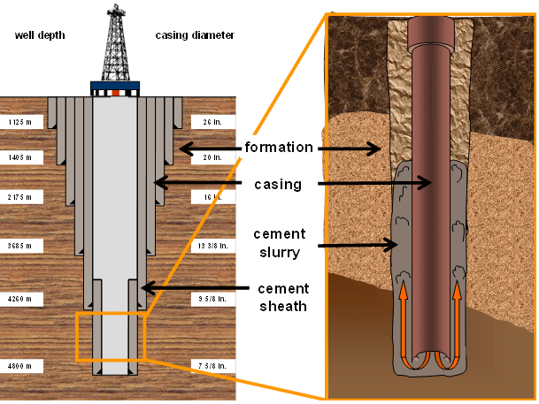
A steel pipe, or casing, is run into the wellbore before an L-shaped cementing head is fixed on top of the wellhead to receive the slurry. Two wiper plugs, the top and bottom plugs, sweep the inside of the casing and prevent the slurry and drilling fluids from mixing.

The bottom plug is introduced into the well before the slurry is pumped into the well behind it. The bottom plug, which works as a one-way valve that allows the slurry to enter the well, is caught just above the bottom of the wellbore by the float collar.

As cement is pumped into the wellbore, pressure is increased until a diaphragm is broken within the bottom plug. This allows the cement to flow through the casing and up outside the casing string. After the proper volume of slurry is pumped, a top plug is pumped into the casing to push the remaining slurry through the bottom plug. The pumps are turned off once the two pumps reach each other, and the slurry is allowed to set.

Pumpability time is the amount of time it takes for the slurry to set. Special types of cement are used to set wellbores at deep depths, under high temperature and pressure, and in corrosive environments.

Reference:
“How Does Cementing Work?” Rigzone. Dice Holdingd, Inc., 1999. Web. 19 Dec. 2014. <https://www.rigzone.com/training/insight.asp?insight_id=317&c_id=1>.

Cementing Operations (Part 1)

Cementing is another stage in well completion that prepares a wellbore for further stages. The operation mainly involves development and pumping of cement into place to protect and seal the wellbore. This way, non-hydrocarbons, especially water, can be prevented from penetrating into the well.

Cementing is used for other purposes, to seal the annulus after a casing string has been run into a well, to seal an area where flow has been reduced or absent (also known as lost circulation zones), to plug an existing well to control its flow, and to plug an abandoned wellbore.

To displace existing drilling fluids and to fill in the space between the casing and the sides of the drilled well, cement slurry is pumped into the well. The slurry is composed of a special mixture of additives and cement, and is left to harden to seal the well from non-hydrocarbons that might try to enter the wellstream. This is also to ensure that the casing is positioned permanently into place.

tbz1e

Cement Preparation

To determine the amount of cement needed, the diameter and the depth of the borehole are measured using a caliper log. Multifinger caliper logs measure the diameter at various locations using mechanical and sonic means to accommodate irregularities and to determine the volume of the openhole.

The required physical properties and proper set of cement are also put into consideration before starting the cementing and pumping operations. Special mixers are used to combine dry cement with water like hydraulic jet mixers, batch mixers, or re-circulating mixers. The result is wet cement known as slurry. Portland cement is used in this process and is calibrated with additives to form one of the eight different classes of cement which is set by the American Petroleum Institute (API)

There are various types additives mixed into the slurry: accelerators can shorten the setting time for the cement, while retarders can prolong its setting time. On the other hand, lightweight and heavyweight additives can decrease or increase the density of the slurry. Other additives can transform the compressive strength of cement, its flow properties, and its dehydration rates. Bridging materials are added to plug lost circulation zones and antifoam additives are included to prevent foaming within the well. Cost reduction efforts call for the use of extenders.


“How Does Cementing Work?” Rigzone. Dice Holdingd, Inc., 1999. Web. 19 Dec. 2014. <https://www.rigzone.com/training/insight.asp?insight_id=317&c_id=1>.


Well Logging (Part II)

Types of Well Logs

Various types of well logs have emerged over time due to technological improvements. Different tools are used to measure and determine subsurface characteristics.

Resistivity Logs measure electrical flow through rocks and sediments. This log determines the types of fluid present. Formation waters are salty and are good electrical conductors, whereas oil and fresh water are poor electrical conductors.

Induction Logs assess the interaction of magnetic force and electric flow to determine resistivity. They are used for oil-based drilling or air drilling wells, which are non-electrically conductive, unlike mud or water wells.

Spontaneous Potential (SP) Logs calculate electrical currents generated between drilling fluids and formation water held in the pore spaces to show the permeability of rocks in a prospective oil well. SP logs are referred to many times to determine whether a rock formation is a shale or a sandstone.

Well Logging Methods


Mud Logs refer to the drilling of fluid or mud to provide buoyancy to the drill and to remove cuttings from the well. Together with the driller’s log, evaluation log, cuttings log, and logs of nearby wells, information from mud logs is used to determine the commercial viability of an oil well.

To retrieve data before, well logging tools were used to be lowered into the well for regular intervals. Directional drilling have pushed scientists to develop non-vertical methods of well logging. With Logging While Drilling and Measurement While Drilling (MWD), logging tools can now be placed at the end of the drilling column so drillers can determine the prospect of an oil and gas well.

As technology makes more headway at this present time, well logs are now computer generated to interpret gathered information immediately while drilling. These logs are sophisticated that not only they can record measurements, but they can also notify drillers of a potential hazard and can transmit data to offsite servers through satellite.

Potential Hazards

Because logging involves tools that are radioactive, electric, and/or sonic in nature, a driller may be at risk of radiation exposure. At best, drillers should wear appropriate personnel protective equipment (PPE) when using the tools. Authorized and qualified personnel should only be the ones allowed to handle logging tools, while other non-essential workers should be kept away from the rig floor and marked-off sites where radiation hazards may be present. Damage to any radioactive logging tools should be reported immediately.

Other drillers can also get injured by unexpected pressure release. To minimize this occurrence, it is highly advisable to check for the presence of trapped pressure before the tool housing is opened.

References:

How Does Well Logging Work? (1999, January 1). Retrieved December 19, 2014, from https://www.rigzone.com/training/insight.asp?insight_id=298&c_id=1

Oil and Gas Well Drilling and Servicing eTool. (n.d.). Retrieved December 19, 2014, from https://www.osha.gov/SLTC/etools/oilandgas/servicing/special_services.html


Well Logging (Part I)

Well logging records the events, subsurface formations, and depth measurements of geologic formations during drilling. Each well log is a detailed record which can include visual observations (geological logs) or physical measurements made through instruments (geophysical logs) penetrated through a borehole. Some types of geophysical logs can be recorded during any phase of an oil well’s life, namely drilling, completion, production, and abandonment. The concept is borrowed from ship logging in which events aboard a vessel are recorded. But instead of plotting a timeline, well logging is recorded through depth.

History

In the early 19th century, well loggers scaled oilfield derricks and kept a simple chronicle of events that happened at certain depths, which include problems, types of formations encountered, drilling speed, and oil and gas flows.

In the early part of the following century, Conrad Schlumberger envisioned the use of electrical measurements to scale and map out subsurface formations. He and his brother Marcel eventually performed the world’s first well log in France in 1927 using resistivity, a measurement of how strongly a given material opposes the flow of electric current. century, well loggers scaled oilfield derricks and kept a simple chronicle

Method

A graph and corresponding notes represent drilling records and well depths. Logging tools are inserted into the well to measure the electrical, acoustic, radioactive, and electromagnetic properties of subsurface formations. To collect data, logging tools are incorporated into the drilling tool or drilling tools are lowered into the wells at regular intervals.

Drillers and engineers use well logs to measure formation thickness, formation tops, porosity, water saturation, temperature, types of formations encountered, presence of oil and gas, estimated permeability, reservoir pressures, and formation dips. Well logging does not only record wellbore events, but also ultimately predicts whether a well is commercially viable or not, and whether casing, cementing, and completion should be run on a well.

Reading a Well Log

A well log includes a header that provides specific information about the well like the operating company and the type of log, as well as the main log section and the graph. The vertical part of the chart represents the depth reached, while the horizontal part represents the measurement scale.

Each major section of the log contains inserts which identifies each curve. Curves on the logs – called traces, readings, or measurements, can be represented by solid, long-dashed, short-dashed, or dotted lines to represent different measurements used on the log. To ensure accuracy, the final part of the log includes the tool calibrations used before and after the log was conducted.

References:

Helmenstine, Anne Marie. “What Is Electrical Resistivity?” Electrical Resistivity Definition. About Education, 11 June 2014. Web. 19 Dec. 2014. <http://chemistry.about.com/od/chemistryglossary/g/Electrical-Resistivity-Definition.htm>.

“How Does Well Logging Work?” How Does Well Logging Work? Rigzone, 1 Jan. 1999. Web. 19 Dec. 2014. <https://www.rigzone.com/training/insight.asp?insight_id=298&c_id=1>.

“Oil and Gas Well Drilling and Servicing ETool.” Oil and Gas Well Drilling and Servicing ETool. Occupational Safety & Health Administration. Web. 19 Dec. 2014. <https://www.osha.gov/SLTC/etools/oilandgas/servicing/special_services.html>.

Wireline Operations

Wireline operations are part of special services in the oil and gas industry. The operations include slicklines and electric lines utilized for perforating, logging, bailing, downhole tool setting, fishing, swabbing, and other workover efforts.

Wirelines

A wireline, also called electric line, is an electric cable used to transmit data regarding the conditions of the wellbore and to lower tools into it. It may consist of single or multi-strand cables that are braided. Aside from gathering data for other workover tasks, wirelines are also used to perform wireline logging.

Slicklines A slickline is a thin non-electric cable inserted into a well to deliver and retrieve wellbore tools like gauges, plugs, and valves. It can also be used to adjust valves and sleeves located downhole, and to repair tubing within wellbore. Wrapped around a drum at the back of a truck, the slickline is raised and lowered into the well by reeling the wire in and out hydraulically.

Wireline Logs

Wireline logs measure properties of well formations using electric lines. They were first developed by the Schlumberger brothers in 1927. Wireline logs are constant downhole measurements sent through wirelines to help drillers, engineers, and geologists make real-time decisions about drilling operations – quite different from MWD and mud logs. Wireline logs assess wellbore dimensions and sonic properties, and can measure conductivity, resistivity, and formation pressure.

The logging tool called a sonde is located at the bottom of the wireline. Measurements are taken by lowering the wireline to the prescribed depth and then raising it out of the well. In an effort to sustain tension on the line, measurements are continuously taken on the way up.

Workover Operations

Workover operations cover remedial work to sustain, restore, and/or enhance production. Although frequent, but not necessarily always, workover operations require production shut-in. a well-servicing unit is used in workover operations to haul things in and out

General Information: Cochran County

Permit approval in Cochran County peaked in 1990 and in 1994 when more than 100 permits were approved for those years alone. The lowest recorded approval rate in the county occurred in 21998 when just under 20 permits were approved. The approval rate this year is just a little better with an approval more than 20 permits. The companies that filed the most number of permits in the area include A.C.T. Operating Company; Silver Creek Oil & Gas, LLC; Apache Corporation; and Tema Oil and Gas Company.

The highest production in the county occurred in 1993 when more than 7,367,000 barrels of oil were produced. This number, however, has been on a decline ever since, with the worst performance in terms of oil production occurring this year with a production of only a little over 2,946,800 barrels of oil.

Since the start of its operations, some 434 operators have gone into its territory. The top leases in the county include the Boyd Oil Lease #005907; Dean, C.S. “A” Oil Lease #005947; Igoe-Smith Oper. Area Oil Lease #005947; Mallet Oil Lease #018149; and North Central Levelland Unit Oil Lease #060557.

Top Producing Operators in Cochran County, TX

  1. Apache Corporation
  2. Bee-Jay Petro, Inc.
  3. Chevron Midcontinent, L.P.
  4. Cross Timbers Energy, LLC
  5. Endeavor Energy Resources L.P.
  6. Energen Resources Corporation
  7. Kimbell Operating Company
  8. Legacy Reserves Operating LP
  9. Moncrief, W. A., JR.
  10. Occidental Permian LTD.
  11. Oxy USA WTP LP
  12. Tema Oil And Gas Company
  13. Vanguard Permian, LLC
  14. Walsh Petroleum, Inc.
  15. Yucca Energy, Inc.

Top Producing Leases in Cochran County, TX

  1. Boyd Oil Lease #005907
  2. Dean, C. S. “A” Oil Lease #006035
  3. Igoe-Smith Oper. Area Oil Lease #005947
  4. Mallet Unit Oil Lease #018149
  5. North Central Levelland Unit Oil Lease #060557
  6. Northwest Mallet Unit Oil Lease #018246
  7. Smith-Igoe Oil Lease #006071
  8. West Levelland Unit Oil Lease #060190
  9. Woodley, F. L. Oil Lease #005998
  10. Wright, J.M. Unit Oil Lease #068120
  11. Xit Unit Oil Lease #060436
Summary of Data in Cochran County, TX
  • 221 Producing Leases
  • 68 Producing Operators
  • 7,784 Drilled Wells
  • 390,824 BBL Of Oil Produced In Jun 2014
  • 190,790 MCF Of Gas Produced In Jun 2014