All posts by wehitoil-admin

General Information: Burleson County

The highest recorded permit approval rate happened during the start of the county’s oil operations in 1990 when more than 200 permits were approved. In the recent years, the county experience a rapid decline in permit approvals with the number not even reaching approvals a year. This year alone, of the 45 permits filed, only 19 were approved. These were filed by companies such as the Apache Corporation; Anadarko E&P Onshore LLC; Williams, Clayton Energy, Inc,; and Halcon Operating Co., Inc.

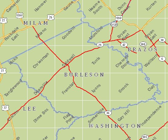
Burleson

In 1993, the county listed its highest production at 6,612,075 barrels of oil for that year alone. However, production has taken a downward turn in the county and it has never reached the same amount in terms of production ever since. In fact, for this year, the production has been recorded at its worst level in the county’s history. Just around 1,322,415 barrels of oil were produced for this year.

Since the start of its operations, some 719 operators have gone into Burleson County’s territory. The top leases in the county include the Ayers-Jackson Unit Oil Lease #025690; Bravenec Oil Lease #026201; Dayton Oil Lease #026402; Fillippone, Marion J. Fee Oil Lease #012060; and Graham, Lois –A- Oil Lease #014783.

Top Leases in Burleson County, TX
• Ayers-Jackson Unit Oil Lease #025690
• Bravenec Oil Lease #026201
• Dayton Oil Lease #026402
• Fillippone, Marion J. Fee Oil Lease #012060
• Graham, Lois -A- Oil Lease #014783
• Horne Management Co. Unit Oil Lease #022949
• Hutchings-Hutchings “A” Unit Gas Lease #148232
• J. H. Buckman E Unit Oil Lease #026249
• Knox Oil Lease #018591
• Lange, William A Oil Lease #013284
• Last Chance Gas Lease #168633
• Lastly Unit Oil Lease #025168
• Machann West Unit Oil Lease #023969
• Moore, Jesse Gas Lease #155376
• Pivonka E Unit Oil Lease #026376
• Rio Brazos Unit Oil Lease #024451
• Smith-Calvin Unit Oil Lease #018861
• T.E. Gibson, JR. Unit 1 Oil Lease #021317
• Tamu Oil Lease #021415
• Viola Davis E Unit Oil Lease #026141

General Information: Aransas County

Permit approvals have occurred in an erratic rate in Aransas County. It experienced its high in 1994 when more than 30 permits were approved. At present, it is experiencing its lowest point with only 1 approval. This same rate also occurred in 2012. Of the 5 permits filed this year, only 1 by the Hilcorp Energy Company was approved. Other companies that operate in the area are T-C Oil Company, Wallis Energy, Inc., and Genesis Producing Company, L.P.

aransas2

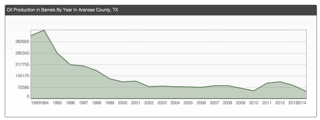
The county experienced its record high in the production of oil when it produced more than 362,925 barrels of oil in 1994 alone. However, since then, a down ward cycle has emerged in the county. As of last count, some 314 operators have gone into the county’s territory.

Top oil leases in the county include Copano Bay State Oil Leases #0122391 and #013557; Lone Wolf Unit Oil Lease #013833; St. Charles Co. Gas Lease #013798, and State Tract 113 Oil Lease #013798.

aransas


Top Leases in Aransas County

  1. Copano Bay State Oil Lease #012391
  2. Copano Bay State Oil Lease #013557
  3. Flinn, Et Al Unit Gas Lease #267429
  4. Grant “B” Gas Lease #188150
  5. Lone Wolf Unit Oil Lease #013833
  6. Nine Mile Point Field Cons. Gas Lease #225679
  7. Nine Mile PT. FLD Consl. G.U. Gas Lease #099731
  8. St. Charles Co. Gas Lease #272321
  9. St. Charles Co. Gas Lease #270893
  10. St. Charles Co. Gas Lease #157177
  11. St. Charles Co. Oil Lease #013798
  12. State Tract 113 Oil Lease #006743
  13. State Tract 12 Oil Lease #012613
  14. State Tract 19 Oil Lease #013678
  15. State Tract 80 Gas Lease #237417
  16. State Tract 94 Oil Lease #013468
  17. State Tract 95 & 96 Oil Lease #012847
  18. Tatton, V.H. Oil Lease #012738

General Information: Atascosa County

Permit approval in Atascosa County spiked in 2012 when more than 250 permits were approved. However in 2014, no permits were approved. Most of the permits were filed by EOG Resources, Inc. and Marathon Oil EF LLC.

Oil production also spiked in recent years in the county. Oil production in the county started in the year 2010. Production in 2012 peaked at over 11,526,625 barrels of oil for that year alone. In its entire history of operations, 966 operators have gone into its territory.

The top leases in the county include Countiss Oil Lease #015787, Emma Tartt Oil Lease #016032, Esse-Smith Ranch Unit A Oil Lease #015650, and Esse-Smith Ranch Unit B Oil Lease #015670.

Atascosa


Top Leases in Atascosa County, TX

  1. Countiss Oil Lease #015787
  2. Emma Tartt Oil Lease #016032
  3. Esse-Smith Ranch Unit A Oil Lease #015650
  4. Esse-Smith Ranch Unit B Oil Lease #015670
  5. Giese Unit Oil Lease #015848
  6. Heard Bower East Unit Oil Lease #015799
  7. Heard Bower West Unit Oil Lease #015760
  8. May-Chapman Oil Lease #016009
  9. Middle McCowen Oil Lease #015638
  10. Pearce Oil Lease #017633
  11. PHZ Unit Oil Lease #015550
  12. R. May B Oil Lease #016361
  13. R.H. Pickens, Et Al “B” Oil Lease #015473
Operator Number
Operator Name
Location
Leases
953755 3 W INVESTMENTS
953810 3 W INVESTMENTS LLC Pleasanton, TX 78064 3
953747 3-G OPERATING COMPANY Houston, TX 77244
953728 3-L DRILLING Abilene, TX 79605
403070 403070 – NAME UNKNOWN
003125 ABRAXAS PETROLEUM CORPORATION San Antonio, TX 78258 5
003140 ABRAXAS PRODUCTION CORPORATION
003575 ACIETEROS, LTD.
003594 ACOCK ENGINEERING & ASSOC., INC.
003598 ACOCK/ANAQUA OPERATING CO., LC
003599 ACOCK/ANAQUA OPERATING CO., LP Corpus Chrsti, TX 78401 8
003664 ACTIVA RESOURCES, LLC San Antonio, TX 78205
008398 ADOBE RESOURCES CORPORATION
008571 AGAPE ENERGY INC.
010074 ALAMO OPERATING COMPANY, L. C. San Antonio, TX 78217
011205 ALCO OIL COMPANY
011260 ALCOR ENERGY, INC. San Antonio, TX 78239
013305 ALLEGRO INVESTMENTS, INC. Victoria, TX 77903
013985 ALLEN & SHUMATE, INC.
013770 ALLEN, HERBERT C. JR.
014155 ALLIANCE EXPLORATION CORPORATION
015630 ALRICH OIL & GAS, INC. Corpus Chrsti, TX 78410
016543 AM-TEX OIL & GAS, INC.
016560 AMAL OIL CO, INC.
018007 AMERICAN COASTAL ENERGY, INC.
018008 AMERICAN COMETRA, INC.
017995 AMERICAN DISPOSAL SERVICES,LTD Sealy, TX 77474
017974 AMERICAN EAGLE RESOURCES, INC. San Antonio, TX 78217
018026 AMERICAN ENERGY DEVELOPMENT CO.
019752 AMERICO ENERGY RESOURCES, LLC Houston, TX 77063 6
020106 AMINEX USA, INC. Somerset, TX 78069
020413 AMMEX PETROLEUM, INC.
020425 AMOCO PRODUCTION COMPANY
020463 AMPAK OIL COMPANY Plano, TX 75074
020554 ANACACHO RESOURCES, INC. New Baden, TX 77870
020582 ANADARKO PRODUCTION COMPANY
020569 ANAQUA OIL & GAS, INC.
022065 ANDERSON, GRACE M. San Antonio, TX 78230 1
024445 ANDREWS & CORKRAN OIL & GAS, INC
024444 ANDREWS & CORKRAN, L.L.C.
026810 AOP OPERATING CORPORATION
027200 APACHE CORPORATION Houston, TX 77056
027800 APPELL PETROLEUM CORPORATION
028678 ARABIE, INC. Georgetown, TX 78627
028802 ARBEN OIL, INC. Coleman, TX 76834
028775 ARCANA OPERATING CO., INC.
029340 ARCO OIL & GAS CO.
029585 ARENA OIL & GAS COMPANY
029710 ARGENT ENERGY (US) HOLDINGS INC. Houston, TX 77010 1
029865 ARGON RESOURCES, INC.

General Information: Brazos County

The peak of Brazos County’s permit approval occurred in 1992 when over 225 permits were approved for that year alone. Only the spike in permit approvals that occurred in 2013 has come close to this record. For last year, over 135 permits were approved. For this year, 45 permits were approved. More than 20 permits were turned down including those filed by the Woodbine Acquisition LLC; Crimson Energy Ptners III, L.L.C.; Apache Corporation; and Halcon Operating Co.,Inc.

As for oil production, it peaked in 1993 when the county produced more than 7,203,425 barrels of oil. Ever since, the production in the county has gone down to an average of more than 1,440,685 barrels of oil. However, in 2013, this figure went up slightly with a production of over 2,881,370 barrels of oil. For this year, the production went down to just over 1,440,685 barrels again.

Since the start of the county’s operations, around 530 operators have gone into its territory. The top leases include the Dansby Heirs Well No. 1 Re Oil Release #025896; Falcon Oil Lease #026935; Hamilton Oil Lease #004060; Hawk Unit Oil Lease #004018; and Jack Irick Unit Oil Lease #026363.

Oil Production in Barrels By Year In Brazos County, TX

brazos

General Information: Bandera County

Permit approval in Bandera County is relatively low compared to other counties. In 2001, the peak of the approvals was recorded over 3 permits for the entire year. The lowest approval rate in the county is recorded at 1 permit approval in the years 1991, 1994, 2005, 2006, and 2009. The last recorded permit approvals occurred in 2011 with 3 permits approved. These permits were filed by the Whiting Oil and Gas Corporation. Among the companies that filed the most number of permits in the county are Gunn Oil Company and Devon SFS, Operating, Inc.

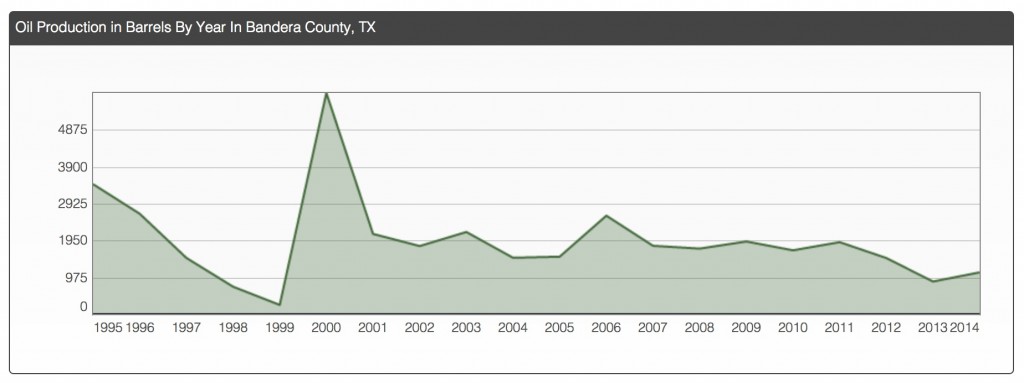
Oil production in the county started strong in 1993 when more than 2,925 barrels of oil were produced. This production spiked in the year 2000 when more than 4.875 barrels of oil were produced. The rest of the years that followed recorded an average production of approximately 1,950 barrels a year.

In its entire history, only 20 operators have gone into its territory. The top lease in the county is the Gallant, James A. Oil Lease #013973.

bandera

Top Leases in Bandera County, TX


  • Carter Gas Lease #253768
  • Gallant, James A. Oil Lease #013973
Operator Number
Operator Name
Location
Leases
055118 BASTROP ENERGY GROUP San Antonio, TX 78231
093620 BRITANCO, L.L.C. Falls City, TX 78113 1
144989 CHAPMAN OIL
172230 CONOCO INC.
198190 DAMSON OIL CORP.
216738 DEVON SFS OPERATING, INC.
253249 EOG (TEXAS) INC.
280875 FOUNDATION ENERGY MANAGEMENT LLC Dallas, TX 75248
338735 GULFSTAR PROPERTIES, INC. San Antonio, TX 78229
339493 GUNN OIL COMPANY Wichita Falls, TX 76307
467262 KINLAW OIL CORPORATION Dallas, TX 75380
518685 MRT EXPLORATION COMPANY
643402 PATTERSON ENERGY CORPORATION New Braunfels, TX 78131 1
712840 RIO PETROLEUM, INC. Amarillo, TX 79102
731767 ROXANNA OIL, INC
823331 STOKES, KING
843108 TEPEE PETROLEUM CO., INC. Houston, TX 77002
895360 WALTERS, R. E.
920478 WHITING OIL AND GAS CORPORATION Midland, TX 79701
950870 ZINN PETROLEUM CO. Houston, TX 77024

What you need to know about Hot Oiling

A hot oil unit is designed to circulate heated fluid into piping, tubing, casing, or tanks for a variety of reasons, including the removal of paraffin and tar-based oils.

Potential Hazard:

  • Fire or explosion hazard from contact with flammable liquids, vapors, or gases.

Possible Solutions:

  • Locate hot oil trucks and tanks a safe distance (100 feet is recommended) from the well and out of the fall line of the derrick, if it is on site. Where impractical, use additional safety measures.
  • Position hot oil units upwind or crosswind from potential sources of flammable liquids, vapors, or gasses. Wind direction indicator should be present and visible to the operator.
  • Shut down hot oiling operation immediately if a leak occurs.
  • Make fire extinguishers readily accessible to the hot oil operator.
  • Avoid parking over or placing lines containing flammable fluids under trucks or other vehicles.
  • Install check valve in the pump line as close to the well head as possible.
  • Inspect all components of the hot oil unit before each use.
  • Shut the burner down if the wind dies.
  • Shut the burner down and reposition equipment if the wind changes direction so as to create a hazard.

Potential Hazard:

  • Being burned by hot oil or hot oil line or frostbite injuries from contact with propane or propane lines.

Possible Solution:

  • Wear proper personnel protective equipment such as heavy padded, insulated, leather gloves

Potential Hazards: Expert Review

  • Unexpected release of pressure

Possible Solutions:

  • Do not connect heavy joints of pipe to the small nipples on the pumping T.
  • Secure all hot oil and discharge lines.
  • Connect the hot oil line directly to the flow line if pump pressure exceeds safe limits (500 psi).
  • Remain clear of pressurized lines.

General Information: Baylor County

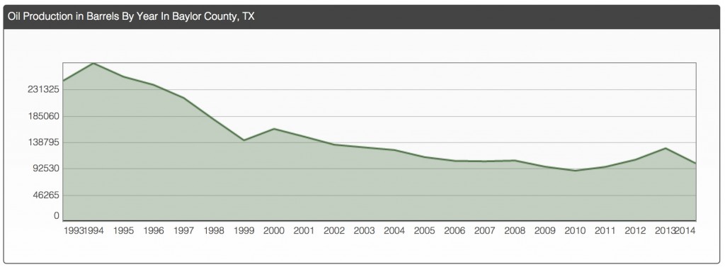
Baylor County started out strong when it started its operations in 1990 when 30 permits were approved. It experienced its peak in permit approvals in 1993 when more than 30 permits were approved. Its lowest approval rate occurred in 2002 when less than 5 permits were approved. In 2014, a little over 10 permits were approved. Of the 28 permits filed in this year, 14 were approved and 14 were denied. These permits were filed by the Wells Oilfield Services, Inc., Clark John M. Inc., and Century Exploration Res, LLC among others.

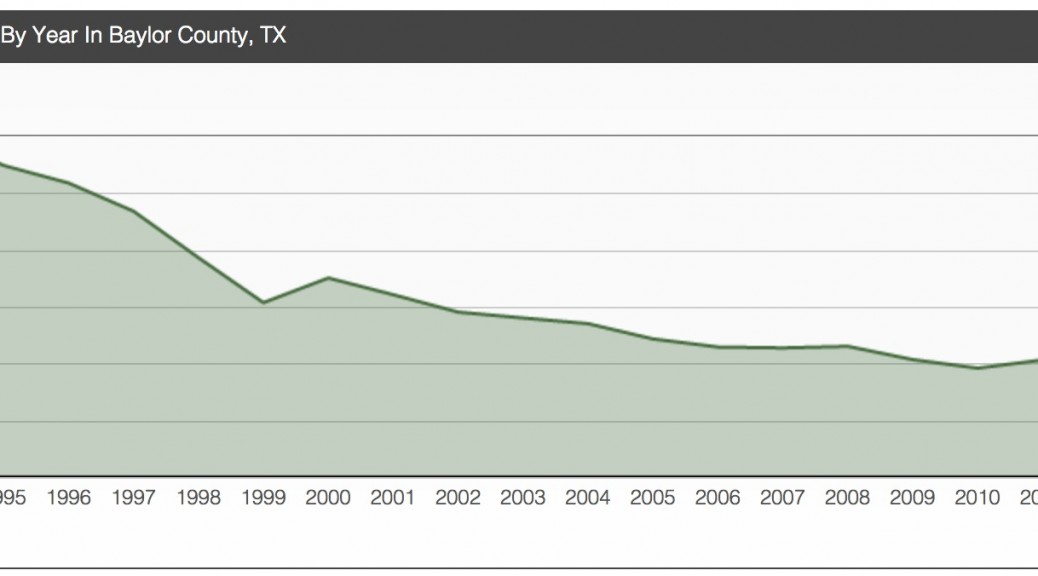
The same trend occurred in terms of the county’s oil production. It started strong in 1994 when it produced over 231,325 barrels of oil for that year alone. From then, however, it went on a downward slope towards the present. In 2014, the recorded production was just a little over 138,795. In its entire history, some 427 operators have gone into its territory. Top leases in the county include the Bormarton Pool Unit Oil Lease #010383, Buckalew Oil Lease #032883, Furr Mineral Trust Oil Lease #032883, Green, F.C. –D- Oil Lease #001433, and Harmel Oil Lease #030571.

baylor

Top Leases in Baylor County, TX
Bomarton Pool Unit Oil Lease #010383
Buckalew Oil Lease #032883
Furr Mineral Trust Oil Lease #032187
Green, F. C. -D- Oil Lease #001433
Harmel Oil Lease #030571
Higgins Pool Unit Oil Lease #013208
Lmy Unit Oil Lease #032544
Sherley, O.C. Oil Lease #032413
Turbeville, J. H. Oil Lease #001437
Upshur Oil Lease #032724
Upshur 59 Oil Lease #032569
Upshur 60 Oil Lease #032729
Upshur 61 Oil Lease #032308
Upshur 72 Oil Lease #032814
Upshur 74 Oil Lease #032653
Upshur 83 Oil Lease #032951

The Mississippian Period and Its Rocks

The term Mississippian is US term used to describe the early Carboniferous period. The term Carboniferous is used in England to identify the period spanning 359.2 to 299 million years ago when the earth was rich with deposits of coal. These deposits were found at that time all over Northern Europe, Asia, and Midwestern and Eastern North America.

The Mississippian Subsystem is differentiated from the Pennsylvanian by the appearance of the conodont Declinognathodus noduliferus, the ammonoid genus Homoceras, and the foraminifers Millerella pressa and Millerella marblensis, though these markers apply only to marine deposits. The distinction between the Mississippian and Pennsylvanian subsystems may also be illustrated by a break in the flora due to transitional changes from a marine to a more terrestrial environment.

The stratigraphy of the Mississippian is distinguished by shallow-water limestones. Some of these limestones are composed of parts of organisms, primarily the remains of crinoids that thrived in the shallow seas. Other limestones include lime mudstones, composed of the carbonate mud produced by green algae, and oolithic limestones, composed of calcium carbonate in concentric spheres produced by high wave energy. Also found in Mississippian strata, though not as common, are sandstones (sedimentary rock composed of quartz sand and cemented by silica or calcium carbonate) and siltstones (rock composed of hardened silt).

At left, scientists in a coal mine have color coded the successive layers of coal ball formation. Each layer represents an individual flood event in the coal swamp. On the right, a scientist observes the evidence of glacial and interglacial strata in Kansas. Glacial periods result in lowered ocean levels, while interglacial periods result in a rise in ocean levels, covering the continental shelf with shallow seas.
Coal beds, which can be up to 11 to 12 meters thick, characterize the late Carboniferous. The forests of seedless vascular plants that existed in the tropical swamp forests of Europe and North America provided the organic material that became coal. Dead plants did not completely decay and were turned to peat in these swamp forests. When the sea covered the swamps, marine sediments covered the peat. Eventually, heat and pressure transformed these organic remains into coal. Coal balls, pockets of plant debris that were preserved as fossils and not converted to coal, are sometimes found within the coal layers.

Multiple transgressions and regressions of the Pennsylvanian seas across the continent can be seen in the rocks, and even counted, because they leave a telltale sequence of layers. As sea levels rise, the layers may go from sandstone (beach), to silty shale or siltstone (tidal), to freshwater limestone (lagoon), to underclay (terrestrial), to coal (terrestrial swampy forest). Then as sea levels fall, one may see a shale (nearshore tidal) grade to limestone (shallow marine) and finally to black shale (deep marine).

Index fossils are the remains of plants and animals that characterize a well-defined time span and occur over a wide range of geography. Fossils of marine life characterize the Mississippian, as shallow epicontinental seas covered the United States at that time. These fossils include solitary corals and Syringopora, tubular colonial corals. Other fossil colonial corals include Stelechophyllum and Siphonodendron. Because conodont fossils are distributed all over the world, they are utilized internationally to date Mississippian rocks.

According to the University of California Museum of Paleontology, “The Mississippian environment of North America was heavily marine, with seas covering parts of the continent. As a result, most Mississippian rocks are limestone, which are composed of the remains of crinoids, lime-encrusted green algae, or calcium carbonate shaped by waves.”

“The stratigraphy of the Mississippian is distinguished by shallow-water limestones. Some of these limestones are composed of parts of organisms, primarily the remains of crinoids that thrived in the shallow seas. Other limestones include lime mudstones, composed of the carbonate mud produced by green algae, and oolithic limestones, composed of calcium carbonate in concentric spheres produced by high wave energy. Also found in Mississippian strata, though not as common, are sandstones (sedimentary rock composed of quartz sand and cemented by silica or calcium carbonate) and siltstones (rock composed of hardened silt).”

General Information: Andrews County

Permit approval only ballooned in the recent years until it peaked in 2011 when Andrews County approved more than 1375 permits for that year alone. This year, however, the number of permits approved only reached a little over 275. The companies that filed the most number of permits in the county were Unitex Oil & Gas, L.L.C.; Ring Energy, Inc.; and Conocophillips Company.

Oil production in the county went on a steady decline from 1991to 2009. In 2010, production started going up until finally reaching its peak in 2013 with a production of over 3,534,5525 barrels. The highest production in the county occurred in 1993 when the county produced above and beyond 3,5345,525 barrels. This year, just a little under 21,207,315 has been produced.

Since it started operations, some 1,175 operators have gone into Andrews County territory. The top leases in the county include Cross Bar Ranch Oil Lease #038014; Fullerton Clearfork Unit Oil Lease #001770; Goldsmith Andector Unit Oil Lease #021193; Mabee 240B Oil Lease #039879; and Mabee Unit Oil Lease #004010.

andres

Top Leases in Andrews County, TX

Cross Bar Ranch Oil Lease #038014
Embar University Gas Lease #184087
Fee “Ao” Gas Lease #229090
Fee “Q” Gas Lease #133915
Fee “S” Gas Lease #134302
Fullerton Clearfork Unit Oil Lease #001770
Goldsmith Andector Unit Oil Lease #021193
Mabee 240B Oil Lease #039879
Mabee Unit Oil Lease #004010
Means /San Andres/ Unit Oil Lease #017503
North Cowden Unit Oil Lease #020164
Phillips University “P” Gas Lease #219754
Three Bar Shallow Unit Oil Lease #043190
University “7-43” Oil Lease #040532
University 12-14 Ne Gas Lease #164187
University 3-14 Ne Gas Lease #152009
University 32a Gas Lease #034232
University 8-14 Gas Lease #166498
University Az Gas Lease #264357
University Block 9 Oil Lease #039152

General Information: Dickens County

Dickens County has had a lot of fluctuations in its permit approvals since the 1990s. It hit its highest level in 2003 when it approved more than 75 permits. Its lowest point is at present with only 11 permits approved. In recent years, the companies that filed the most number of permits were Halliburton Operating Company, Schalk Oil Company, Inc, and Buck Wheat Reseouces, L.P.

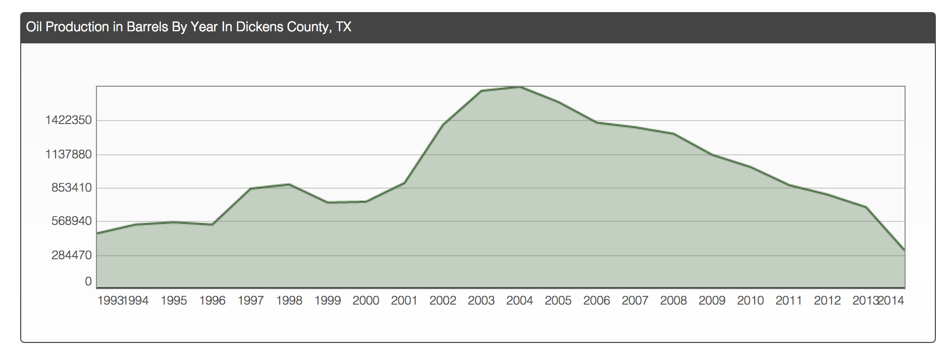
The county experienced its highest production of oil in 2004 when it produced over 1,422,350 barrels of oil for that year alone. Its lowest production, on the other hand is at present as it has only produced a little over 284,470 barrels of oil.

Since the start of its operations, the county has had 162 operators come into its territory. The current top leases in the county are Bell Oil Lease #068356; Bell “A” Oil Lease #068357; Hill-Neal Unit Oil Lease #068637; Jones A Oil Lease #069467; and Kathi Oil Lease #069914.

Oil and Gas Operators in Dickens County, TX
dickens

Top Leases in Dickens County, TX

  • Bell Oil Lease #068356
  • Bell “A” Oil Lease #068357
  • Hill – Neal Unit Oil Lease #068637
  • Jones A Oil Lease #069467
  • Kathi Oil Lease #069914
  • McArthur B Oil Lease #070127
  • Navigator Unit Oil Lease #068035
  • Pitchfork CCCC Oil Lease #069048
  • Pitchfork Toreador “22” Oil Lease #068264
  • Trifecta (Tannehill “B”) Unit Oil Lease #069557

dickens

Operator Number
Operator Name
Location
Leases
007937 ADKINS, R. L. CORP.
014157 ALLIANCE OGO, LP Pleasanton, CA 94588
015138 ALPINE PETROLEUM Abilene, TX 79608
023900 ANDOVER OIL COMPANY
029700 ARGEE OIL COMPANY
029870 ARGONAUT ENERGY CORPORATION
034450 ASHLAND EXPLORATION, INC.
034500 ASHLAND OIL, INC.
037680 AUSTRAL OIL COMPANY INCORPORATED
054313 BASIC ENERGY SERVICES, L.P. Fort Worth, TX 76102
056555 BAXTER, KELLY H.
068030 BERRY EXPLORATION CORPORATION
068360 BETTIS, BOYLE & STOVALL Graham, TX 76450
072604 BLACK DOME ENERGY CORPORATION
077629 BOB & TED’S OPERATING
083041 BORDERS, DELBERT L. INC. Wichita Falls, TX 76307
092480 BRIDWELL OIL CO. Wichita Falls, TX 76307 1
041860 BTA OIL PRODUCERS
105675 BUCK WHEAT RESOURCES, L.P. Eastland, TX 76448
108800 BURK ROYALTY COMPANY
108788 BURK-GUNN OIL CO. Wichita Falls, TX 76307 1
127600 CAMP OIL COMPANY
129008 CANAN MOWREY OPERATING, LLC Wichita Falls, TX 76308 28
120048 CCV, INC.
141032 CENERGY EXPLORATION COMPANY
141150 CENTEX OIL & GAS, INCORPORATED
149454 CHISHOLM OPERATING, INC. Abilene, TX 79606 10
150683 CHOLLA PETROLEUM, INC. Dallas, TX 75225 2
159500 CLEAR FORK, INCORPORATED Abilene, TX 79604
161165 CLINTON OIL CO.
185980 COX, JOHN L.
188555 CREED OPERATING CO., LLC Wichita Falls, TX 76301 1
188584 CREGO EXPLORATION Dallas, TX 75243 2
189904 CRESTON PETROLEUM CORP. Dallas, TX 75234 1
196805 D. & H. SERVICES INC.
195925 D. W. R. OIL CO., INC. Merkel, TX 79536
196279 D.J.F. SERVICES, INC. Holdenville, OK 74848 2
208872 DEAN ENERGY, INC. Midland, TX 79702
213275 DELRAY OIL, INC. San Antonio, TX 78209
213565 DELTA-GULF, INC.
222282 DOMINION OKLAHOMA TEXAS E&P, INC Richmond, VA 23219
227845 DRACO ENERGY, INC. Midland, TX 79702
228125 DREYFUS, LOUIS NATURAL GAS CORP
235895 DURANGO OPERATING CO., INC.
238558 E.G. OPERATING
239171 EASTERN ENERGY CORPORATION
251998 ENERGY RESOURCE & DEVELOP., CORP
256931 EXCO RESOURCES, INC. Dallas, TX 75251
257697 FAGAN-O’CONNOR, INC.
266310 FERGUSON OIL & GAS CO., INC.